


Forest cover in Gundia river catchment down by 10 p.c.: report
Forest cover in Gundia river catchment down by 10 p.c.: report
Mangalore Today News Network
Mangaluru, Sep 19, 2015 : Area under forests in the Gundia river catchment in the Western Ghats has reduced from 70.74 per cent to 61.15 per cent in the last one-and-half decade, according to a recent report from the Indian Institute of Science (IISc), Bengaluru. The Yettinahole is a tributary of the Gundia.

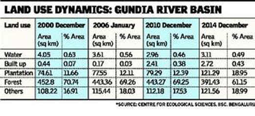
The report titled “Environmental Flow Assessment in Yettinahole. Where is 24 tmcft to divert?” has also pointed out that water yielding area in the Gundia river catchment has shrunk from 0.63 per cent to 0.46 per cent during the same period.
Contrary to the claims of some political leaders that the Yettinahole diversion project is not meant to divert the Netravati river, the report from the Energy and Wetlands Research Group, the Centre for Ecological Sciences at the institute, points out that the Yettinahole finally joins the Netravati through the Gundia river.
The report said that the Yettinahole is one of the perennial water sources in the Western Ghats.
It said: “Yettinahole, originating at an altitude of 950 m in Sakleshpur taluk of Hassan district, is a tributary of the Gundia (which joins the Kumaradhara) and finally drains into the Netravati.”
It said that the Gundia is formed by two streams — the Yettinaholé and the Kempuholé. Then, Gundia is joined by two more streams — the Kadumaneholé and the Hongadahalla — to form a river course. The Gundia catchment region is surrounded by the Hemavathi river watershed on its right, the Barapole river catchment on its left and the Netravati in the downstream.
The report, released in April, said that the area under forests in the Gundia river catchment has been reduced by 61.37 sq km that is from 452.80 sq km in December 2000 to 391.43 sq km in December 2014.
Water yielding area has shrunk by 0.94 sq km, from 4.05 sq km to 3.11 sq km, during the same period. At the same time, the report pointed out that the area under plantation went up by 46.68 sq km in area, from 11.66 per cent (74.61 sq km in area) to 18.95 per cent (121.29 sq km in area).
It said that a sustainable option to meet the water requirements of arid regions is through decentralised water harvesting (through tanks, ponds, lakes, etc.), rejuvenation or restoration of existing lakes/ponds, recharging groundwater resources, planting native species of herbs and plants in the catchment, and implementation of soil and water conservation through micro-watershed approaches.
Courtesy :The Hindu
 Write Comment
 E-Mail
 Facebook
 Twitter
  Print
Print - 5 of family killed in accident near Karnataka’s Chitradurga
- Ranveer Singh offers prayers at Chamundeshwari Temple in Mysuru after Kantara mimicry row
- ED raids former Kerala CM Pinarayi Vijayan’s properties, daughter’s firm in CMRL case
- Byju’s founder Byju Raveendran sentenced to six months in jail by Singapore court
- NEET-UG 2026 paper leak: CBI arrests doctor, coaching centre teacher; total arrests rise to 13
- ’I lost my daughter, Mamata Banerjee lost her chair’: RG Kar victim’s mother
- Three AIADMK MLAs resign, join TVK; EPS alleges ‘Horse Trading’
- CNG price goes up by Rs 2 a kg; to now cost Rs 83.09 in Delhi
- ’Prices have hit unimaginable levels’: N Sitharaman says focus on three ’Fs’
- ‘Inflation: Rahul Gandhi targets Centre over rising fuel price hikes
- Modi govt has sprinkled petrol to burn common people’s savings: Kharge lashes out at BJP
- Congress in Karnataka playing double game over SIR of electoral rolls: Nitin Nabin
- Bakrid celebrated with religious fervour across Mangaluru, Udupi
- Udupi: Two arrested for alleged rape and cheating of minor girl
- Mangaluru: Four students injured after tipper lorry hits bus at Haleyangadi
- Mangaluru: Three arrested for assaulting beat police personnel near Kodikal
- Mangaluru: Two arrested in Mulki bike theft case
- DK Automobile & Tyre Dealers’ Association signs MoU with Srinivas University to strengthen industry–academia collaboration
- Mangaluru’s Denis Dsilva elected as National President of Global Business Fellowship India
- Puttur woman loses Rs 2.92 lakh to cyber fraudsters posing as bank officials
- Sahyadri to host 3rd IEEE International Conference COSMIC-2026
- Udupi: Fisherman goes missing at sea near Malpe harbour
- Photographer succumbs to injuries after road accident near Belthangady
- Gundya: Woman killed, seven injured in KSRTC bus–tempo traveller collision
- DK DC orders strict action against illegal cattle slaughter, transport ahead of Bakrid
- Mangaluru Student Goes Missing; Ullal Police Register Case
- APD Foundation Joins WHO Civil Society Commission
- Daiva’s prediction comes true: Janardhan Reddy walks free from jail
- Skills and Competencies Take Center Stage at MSN Dialogue Series
- Court remands Maoist Lakshmi to six-day police custody
- Sandhya Shenoy honored with Society for Materials Chemistry Medal-2024
- White Cornus Apartment in Mangaluru
- City girl wins first place in state-level spell bee competition
- Alleged ‘Love Jihad’ Case in Mangaluru: Woman left home voluntarily, says police
- Girl fatally struck by reckless two-wheeler near Belman
- New residential complex for the judges inaugurated in Mangaluru
- Absconding accused nabbed after 8 years
- Truck with cylinders turns turtle in Beltangady
- Bhoota Kola artist dies of cardiac arrest
- Development of the country should be our goal: Ganesh Karnik


- Local Search
- Classifieds
- CITY INFORMATION
- TRAVEL
- TOURIST INFORMATION
- HEALTH CARE
- MISCELLANEOUS
© 2024 All rights reserved. MangaloreToday