


Ahead of Cyclone Fani, red alert for coastal Tamil Nadu
mangaloretoday network
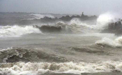
Chennai, April 25: The Indian Meteorological Department on Thursday issued a red alert for Tamil Nadu and Puducherry on April 30 and May 1 saying heavy to very heavy rainfall is likely in the southern state and the union territory. The IMD and other private weather forecasters have predicted that a low pressure formed in the Bay of Bengal is likely to develop into a cyclone which would be named ‘Fani’.
According to the IMD, if the low pressure transforms into a cyclone, it will move in a western and north-westerly direction where Tamil Nadu lies.
“A well low-pressure area lies over East Equatorial Indian Ocean and adjoining the southeast Bay of Bengal. It is very likely to intensify into a depression during the next 24 hours over East Equatorial Indian Ocean and adjoining central parts of south Bay of Bengal and into a Cyclonic Storm during the subsequent 24 hours over southwest Bay of Bengal and adjoining Equatorial Indian Ocean. It is very likely to move northwestwards along the east coast of Sri Lanka near north Tamil Nadu coast on April 30, 2019,” the IMD alert reads.
IMD’s Chennai regional director, S Balachandran said, “We are monitoring the system. Only on April 27 can we predict when and where the cyclone will make landfall.”
He also advised fishermen not to venture into the sea for the next week.
Though the IMD has not predicted the exact place where Cyclone Fani would make landfall, Nagapattinam-based private weather analyst Selva Kumar, who had correctly predicted that Cyclone Gaja will cross the shores between Nagapattinam and Vedaranyam coasts in November last, has claimed that Cyclone Fani will cross the shore between Manamelkudi (Pudukottai district) and Adhirampattinam (Thanjavur district) coastal areas.
The weather tracking website Skymetweather.com has observed that the system may strengthen as a tropical storm on the evening of April 27 or on the morning of April 28.
“It is to be named Cyclone Fani. By this time, it would have reached Southwest Bay of Bengal, close to Sri Lanka. Gradually, it will arrive in close proximity of the North Tamil Nadu coast in the Southwest Bay of Bengal. Weather models are showing the tendency of the system to move north-northwestwards and re-curve thereafter,” the skymetweather.com said in its blog.
The weather forecast website has also predicted that it is already a slow-moving system. “If the system re-curves, it is likely to further make it slower. This means that the system may become more intense and spend more time in the proximity of the Tamil Nadu coast, resulting in good rains over the state, including Chennai for a prolonged period,” the prediction reads.
If the cyclone makes landfall, it will be the second one in the state within six months. Cyclone Gaja hit the state in November. In the cyclonic devastation, 63 people died and thousands of houses were damaged in Nagapattinam, Thanjavur, Thiruvarur and Pudukkottai districts.
With the IMD sending out a red alert, district administrations of Pudukkottai, Thanjavur, Nagapattinam, Cuddalore and Thiruvarur have advised fishermen not to venture into the sea for the next few days.
 Write Comment
 E-Mail To a Friend
 Facebook
 Twitter
  Print
Print - Tulu Play “Aaye Aan Mage” Wins Dharmasthala Rathnavarma Heggade Award
- Rowdy-Sheeter Detained Under Goonda Act in Udupi
- Adopting Five Core Values Key for India to Become Developed Nation by 2047: Dr. Prahlada Ramarao
- Udupi: Sachin Tendulkar-Named Miyawaki Forest Launched in Katapadi
- NMPA Launches Merchant Navy Week with Flag Pinning Ceremony
- Easter Vigil Observed with Fervour in Coastal Districts; Bishop Calls for Peace and Unity
- Siddaramaiah to Campaign in Kerala’s Manjeshwar; Border Seat Sees Intense Political Activity
- Narendra L. Nayak felicitated at KUPMA District Committee inauguration
- Gurupura: 3rd Moolur–Addur Jodukare Kambala inaugurated
- Udupi: Woman living alone in mental distress rescued, hospitalised
- Ex-Lokayukta Santosh Hegde collapses at Bengaluru event, hospitalised; condition stable
- Konaje: Clash between private engineering college students, video goes viral
- Bantwal: Boliyar resident held for MDMA sale
- Missing Trekker Found Safe After Four-Day Search in Kodagu
- Governor Seeks Review of Grading-Only System for Third Language in SSLC
- India Resumes Iranian Oil Imports Amid Middle East Supply Disruptions
- US Rescues Downed F-15 Pilot in ‘Daring’ Operation, Says Trump
- India-flagged LPG tanker Green Sanvi crosses Strait Of Hormuz, 2 more in line
- 2 US fighter jets, Black Hawk choppers hit by Iran, 2 pilots rescued, 1 missing
- ‘Contesting For Women’s Safety’: RG Kar victim’s mother enters West Bengal poll battle
- Annamalai breaks silence after BJP denied him ticket for Tamil Nadu polls: ‘I decided...’
- Hubballi: Gym trainer assaulted over rape, ‘love jihad’ claims; probe on
- Nine family members killed as car plunges into well in Maharashtra’s Nashik
- India-bound US-sanctioned ship carrying Iranian oil reroutes midway to China
- Tamil Nadu Assembly polls: BJP releases list of 27 candidates; Annamalai left out
- Mangaluru Student Goes Missing; Ullal Police Register Case
- APD Foundation Joins WHO Civil Society Commission
- Daiva’s prediction comes true: Janardhan Reddy walks free from jail
- Skills and Competencies Take Center Stage at MSN Dialogue Series
- Court remands Maoist Lakshmi to six-day police custody
- Sandhya Shenoy honored with Society for Materials Chemistry Medal-2024
- White Cornus Apartment in Mangaluru
- City girl wins first place in state-level spell bee competition
- Alleged ‘Love Jihad’ Case in Mangaluru: Woman left home voluntarily, says police
- Girl fatally struck by reckless two-wheeler near Belman
- New residential complex for the judges inaugurated in Mangaluru
- Absconding accused nabbed after 8 years
- Truck with cylinders turns turtle in Beltangady
- Bhoota Kola artist dies of cardiac arrest
- Development of the country should be our goal: Ganesh Karnik


- Local Search
- Classifieds
- CITY INFORMATION
- TRAVEL
- TOURIST INFORMATION
- HEALTH CARE
- MISCELLANEOUS
© 2024 All rights reserved. MangaloreToday