


Nepal’s PM claims Kalapani area, tells India to ‘withdraw’
Mangalore Today News Network
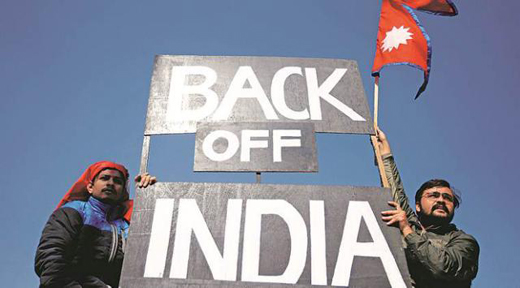
Katmandu, Nov 18, 2019: With protests mounting, Nepal Prime Minister K P Oli said on Sunday that the Kalapani area at the tri-junction of Nepal, India and Tibet belonged to Nepal, and “India should immediately withdraw its army from there”.
It was Oli’s first public response to a controversy triggered by official India maps released recently that included Kalapani, an area located on the western edge of Nepal. While there was no official response from Delhi, sources reiterated that the maps depicted India’s “sovereign territory accurately” and there had been no revision in the boundary with Nepal, yahoo reported.
Addressing a meeting organised by the Nepal Yuva Sangam, the youth wing of the ruling Nepal Communist Party, Oli said, “We will not allow even an inch of our territory to be occupied by any country, India must vacate it.” However, he overruled suggestions that Nepal come out with an amended map including the contested areas. Dialogue will follow after India “withdraws its army from our land”, Oli said.
Nepal has seen protests by both ruling and opposition parties over the India maps. Participants at an all-party meeting called by Oli three days ago, including former prime ministers and ex-foreign ministers, asked him to take up the issue with India immediately.
Kalapani, kalapani India Nepal, India Nepal relations, jammu kashmir bifurcation, india new map, india map jammu kashmir, nepal border india map
The new political map of India, recently released by the government to account for the bifurcation of Jammu and Kashmir, shows Kalapani as part of India
The new maps were released by India to factor in the newly-created Union Territories of Jammu and Kashmir (J-K) and Ladakh. These maps include Pakistan Occupied Kashmir as part of J&K, and Gilgit-Baltistan, also controlled by Pakistan, in Ladakh.
In a statement on November 6, the Nepal Foreign Ministry said, “The government is clear that the Kalapani area lies within Nepalese territory.”
In a reaction a day later, the Indian Ministry of External Affairs said, “Our map accurately depicts the sovereign territory of India. The new map has in no manner revised our boundary with Nepal... The boundary delineation exercise with Nepal is ongoing under the existing mechanism. We reiterate our commitment to find a solution through dialogue in the spirit of our close and friendly bilateral relations.”
The statement added that India and Nepal should guard against “vested interests trying to create differences between the two”.
 Write Comment
 E-Mail To a Friend
 Facebook
 Twitter
  Print
Print - LS Elections 2024: Phase 1 Of General Elections Record 62% Voter Turnout
- Yedapadavu: Several vehicles damaged as truck lost control and rams into them
- LS polls: Prohibitory orders across DK from April 24 to 26
- Uppinangady: 13 year old boy ends life
- Several parts of DK, Udupi receive good rainfall
- Union govt. gave grants over â‚ą1 lakh crore to Dakshina Kannada in the last decade: MLA Kamath
- Karnataka government focusing on harnessing more solar power, says Energy Minister
- Pedestrian fatally run over by tanker at Kulur
- Karkala: Forest fire engulfs vast tracts of land
- Maintenance works in Palakkad division; changes in train services
- Udupi: Bike-tipper collision claims rider’s life
- Kadaba acid attack victim writes CET in Mangaluru
- EC dismisses concerns as Kasaragod mock poll sparks row
- Doordarshan’s new ’Saffron’ logo sparks criticism, ex-boss takes a jibe
- 7 dead after boat with 50 passengers capsizes in Odisha’s Mahanadi river
- ABVP workers stage protest in Hubballi condemning female student’s murder
- LS elections 2024: PM Narendra Modi to campaign in Bengaluru and Chikkaballapura on April 20
- Mysuru man claims attacked for making song on PM Modi, police to probe
- Karnataka Congress corporator claims daughter killed due to ’love jihad’
- "Are we in Pak or Afghanistan?" Actor, husband attacked by mob in Bengaluru
- Air India suspends flights to Tel Aviv till April 30 amid Iran-Israel clash
- H5N1 strain of bird flu found in raw milk from infected animals: WHO
- Not love jihad: Karnataka govt amid outrage over woman’s murder in college
- Indian embassy advises Indians to reschedule non-essential travel as UAE reels under historic floods
- Almost 0% voting in 6 Nagaland districts over separate territory demand
- New residential complex for the judges inaugurated in Mangaluru
- Absconding accused nabbed after 8 years
- Truck with cylinders turns turtle in Beltangady
- Bhoota Kola artist dies of cardiac arrest
- Development of the country should be our goal: Ganesh Karnik
- Container truck gets stuck under Modankap railway bridge
- Truck crushes bike’s pillion rider near BC Road
- Head constable dies of heart attack
- Udupi: PDO dismissed over financial irregularities
- CREDAI to resume Skill Development Program for Construction Workers in Mangaluru
- John B Monteiro elected president of Rachana Catholic Chamber of Commerce & Industry
- Sudhanshu Rai elected district president of All College Student Association
- Chief Minister to visit Mangaluru, Udupi on August 1
- Nitte University awards PhD degree to Tina Sheetal D’Souza
- Sachitha Nandagopal honoured by CMTAI for Community Service


- Local Search
- Classifieds
- CITY INFORMATION
- TRAVEL
- TOURIST INFORMATION
- HEALTH CARE
- MISCELLANEOUS
© 2024 All rights reserved. MangaloreToday